
News Summary
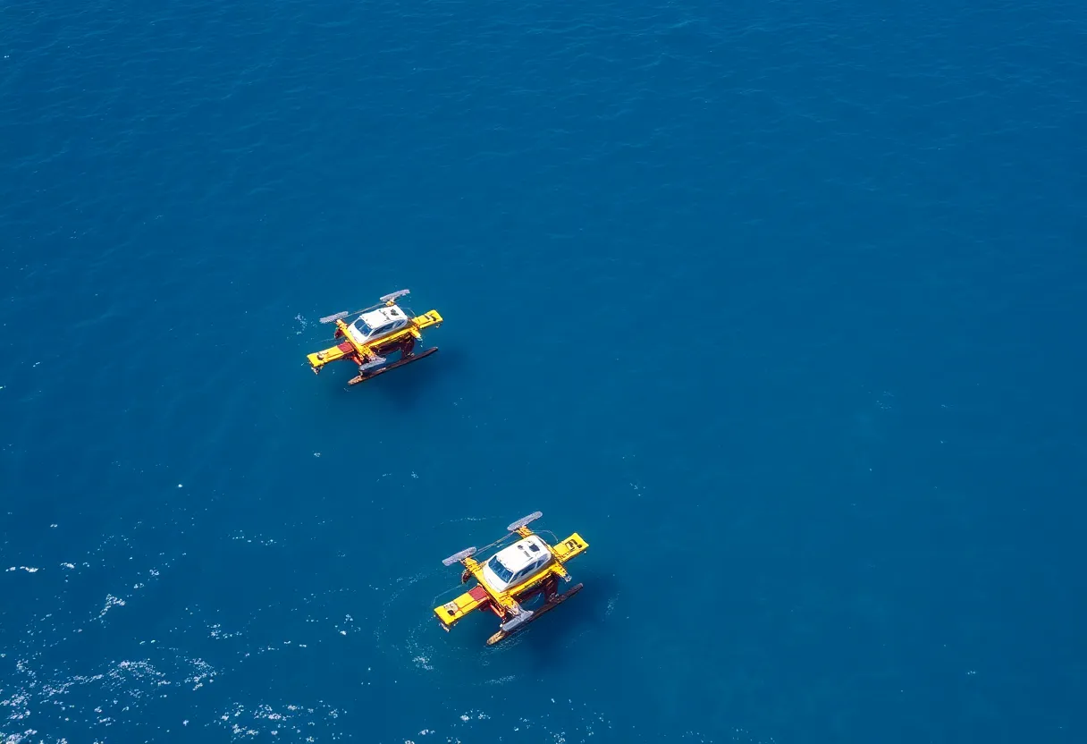
Saildrone has initiated an ocean mapping project utilizing two uncrewed surface vehicles (USVs) to explore and produce high-resolution maps of Florida’s seafloor. This project, part of the Florida Seafloor Mapping Initiative, aims to replace outdated nautical charts with detailed data. The mission focuses on the Middle Grounds area, enhancing coastal resilience and safety. Supported by state and federal agencies, this environmentally sustainable project will use wind and solar power for prolonged mapping missions and aims to assist in hurricane preparedness.
Exciting Ocean Mapping Project Launches Off the Coast of Florida!
Clearwater, Florida – In a thrilling development for ocean science and conservation, two uncrewed surface vehicles (USVs) have been launched by Saildrone, a California-based maritime defense and oceanographic survey company. This innovative venture aims to deeply explore and map the seafloor along the stunning coastline of Florida as part of the larger Florida Seafloor Mapping Initiative (FSMI).
Florida’s Vast Coastline Needs Updating
As you may know, Florida boasts the second-largest coastline in the United States, with an impressive stretch of 1,348.37 miles (or 2,170 kilometers), just behind Alaska. However, much of the existing nautical charts rely on outdated and low-resolution data. That’s where Saildrone’s two Voyager USVs come into play! These high-tech explorers will help illuminate the ocean floor by replacing those old charts with high-resolution seafloor data.
Mapping Middle Grounds: An Essential Mission
The two Voyager USVs are currently working in an area known as Middle Grounds, located about 80 miles (130 kilometers) northwest of St. Petersburg. This mission is no small feat, as it encompasses a breathtaking area of 2,817 square kilometers of seafloor. With a price tag of 1.6 million dollars, the project is not just a splash in the ocean. It’s a concerted effort supported by federal and Florida state agencies, alongside various community stakeholders.
High-Tech Tools for High-Quality Data
Equipped with NORBIT WINGHEAD i80s echo sounders, these USVs are truly amazing. These devices will enable meticulous high-resolution mapping of the ocean floor, while the drones themselves are also loaded with radar, AIS, and cameras, enhancing maritime domain awareness. This means better protection for the environment and smoother sailing for those navigating the waters!
Solar and Wind-Powered USVs for Sustainable Mapping
The beauty of these uncrewed surface vehicles is their commitment to sustainability. Powered primarily by wind and solar energy, these USVs can carry out long-duration missions that may last for several months. This environmentally friendly approach allows for extensive ocean exploration while minimizing harm to the delicate marine ecology.
Improving Coastal Resilience and Safety
One of the keys to this ambitious initiative is the impact it will have on coastal resilience. The data gathered will prove invaluable in predicting storm surge impacts and updating navigational charts. More accurate charts can assist in identifying navigation hazards, which, in turn, can lead to better protection for offshore infrastructure.
Addressing Coastal Vulnerability
As Florida residents know, hurricanes pose a serious threat to coastal communities. This mapping project aims to not just update data, but also assist in evaluating coastal vulnerability and the effectiveness of restoration projects. By highlighting areas at risk and providing quality data, local governments can make more informed decisions to enhance community preparedness.
Saildrone’s Track Record
Saildrone isn’t new to these waters. They have previously deployed Voyager USVs for missions in places like the Gulf of Maine, gathering crucial data on deep-water coral habitats. Their ocean research efforts are impressive, totaling over 1,600,000 nautical miles and more than 46,000 days at sea!
More to Come!
The Florida Seafloor Mapping Initiative is building on previous projects aimed at high-resolution seafloor data collection. It is clear that the data captured during this mission will play a critical role in safeguarding Florida’s beautiful coastal landscapes. So, stay tuned for more updates as this fantastic ocean mapping adventure unfolds!
Deeper Dive: News & Info About This Topic
HERE Resources
St. Petersburg School Gains New Learning Opportunities at Clam Bayou
State of Science Event Set for St. Petersburg in 2025
Florida Invests $1.66 Million in Saildrone for Enhanced Gulf of Mexico Seafloor Mapping
Additional Resources
- WorkBoat: Saildrone Launches Florida Mapping Mission
- Wikipedia: Florida
- Inside Unmanned Systems: Saildrone Begins First Unmanned Survey of Florida’s Coastal Waters
- Google Search: Florida Seafloor Mapping Initiative
- Saildrone Press Release: Florida Seafloor Mapping FSMI Contract
- Encyclopedia Britannica: Oceanography
- ABC7 News: Hurricane Milton and Saildrone
- Google News: Marine Data Collection